
Landslides destroyed many roads, including the Vunga Corridor, which is under rehabilitation.
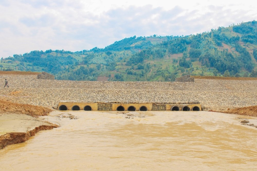
The government has completed a flood retention dam that can hold two million cubic meters of floodwater along the River Sebeya in Western Province.
The dam along River Sebeya was completed after floods and landslides that hit Western and Northern provinces in May 2023. The disasters killed 135 people, leaving 20,326 people homeless.
Floods originate from the Sebeya River catchment area in the districts of Rubavu, Rutsiro, Nyabihu, and Ngororero in the Western Province.
Currently, the nation is carrying out flood control measures while grappling with severe rainfall causing devastating floods. Due to the intense flooding, parts of Kenya, Burundi, and Uganda are in distress. In Kenya, 35 individuals have lost their lives since mid-March in floods that have impacted over 100,000 people, according to the UN.
On Friday, April 24, Kenyan President William Ruto directed the formation of a multi-agency response team to deal with ravaging floods in the country.
Between September 2023 and April 7, 2024, flooding affected approximately 203,944 people in Burundi, resulting in the destruction of 19,250 homes and 209 classrooms.
Since May 2023, when the country experienced severe floods and landslides, the Rwanda Water Resources Board (RWB) has been taking various actions to mitigate these disasters and construct infrastructure that can withstand climate challenges.
“Sebeya Retention Dam marked a pivotal milestone in flood mitigation efforts. The dam functions to control the release of water by slowly ensuring a controlled flow downstream,” said Emmanuel Rukundo, the Director General of the water resources board.
The dam is located upstream in Kanama Sector in Rubavu District.
He said that 14 hotspots were identified along the Sebeya River, emphasizing the urgency of strategic interventions to mitigate the risk of further devastation.
Construction of the flood retention dam focused on seven out of 14 identified hotspots along the Sebeya River, spanning nearly 1.3 kilometers.
“These interventions aimed to reinforce vulnerable sections and minimize the risk of further flooding. However, other remaining hotspots will also be constructed in the coming fiscal year,” he noted.
The rehabilitation of the Gisunyu gully (drainage way) included the creation of a network of ponds, comprising one main pond and 94 smaller ponds, with a combined detention capacity of 2,500 cubic meters, serving as a crucial buffer against excess water runoff.
Among other interventions, there are also upgrades to the Nyundo Bridge by significantly enhancing its conveyance capacity from 12 to 80 cubic meters.
“Additionally, wing walls were constructed upstream and downstream to redirect overtopping water back into the channel, mitigating the risk of structural damage,” Rukundo said.
Two additional dams on the way
According to Rukundo, two additional dams are constructed in the Sebeya catchment areas in the Rutsiro and Nyabihu sites to regulate water flow further and minimize the risk of flooding. “However, this will require detailed study, which has been started,” he said.
Rehabilitation work on three identified hotspots at bridges, he said, mainly increases their conveyance capacity, ensuring uninterrupted passage during flood events.
“Continued construction of retaining walls at specific hotspots characterised by sharp meanders and low river banks, aiming to fortify vulnerable areas and prevent erosion-induced flooding, is planned,” he said.
Managing volcano floods
Through the completed volcano flood-management project, Rukundo said, flood retention ponds have been established to attenuate water upstream, reducing the volume and velocity of water flowing downstream during heavy rainfall.
The banks of critical gullies have been elevated to control overflow and prevent water from spilling into surrounding areas.
“Both natural-based and structural solutions have been employed to stabilize the banks of the gullies, reducing erosion and the risk of bank collapse during flooding. Bridges have been provided where the gullies intersect roads, ensuring the uninterrupted flow of traffic and reducing the risk of road damage during flooding,” he said.
Out of a total of 19 main gullies identified in the volcano area, Rukundo said, nine critical gullies have been completed, with five in Musanze (Susa, Muhe, Cyabirengo, Ruvumu, Nyabutoshwa upstream, Nyabyungo downstream, and Nyabutoshwa downstream) and two in Burera (Muhabura-Mbandana and Nyarubande upstream).
Meanwhile, two retention ponds are under construction along the Cyuve gully to further attenuate water upstream and reduce downstream flooding.
“Those flood infrastructure measures are expected to be completed early before the end of this year,” Rukundo noted.
He said there are still 10 main gullies that need to be assessed, planned, and worked on to ensure comprehensive flood control in the volcano area.
“Continuous monitoring and maintenance of the implemented flood control measures are essential to ensure their effectiveness and longevity.”
Volcano flood control project extended
Rukundo stated that an ongoing feasibility study for flood control measures in the Volcano region and Vunga Corridor will identify other new gullies.
Communities devastated by flooding along the Mukungwa River in the Northern and Western Provinces in May 2023 could find relief in a $300 million (approx. Rwf 382 billion) initiative set to commence implementation soon in the volcano region and Vunga Corridor.
According to Rukundo, the project dubbed “Volcano Community Resilience Project” in the volcano region and Vunga Corridor will be implemented in eight districts, which include Musanze, Nyabihu, Rubavu, Burera, Gakenke, Ngororero, Muhanga, and Rutsiro to minimize the floods in these regions.
“We are at the stage of feasibility studies, and the implementation shall start earlier in 2025.”
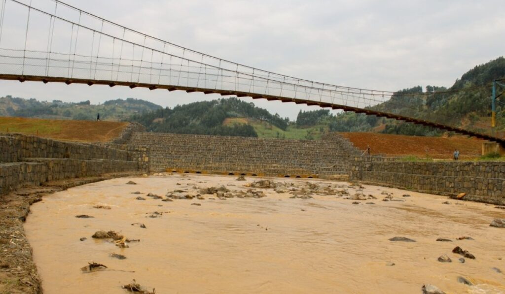
The Mayor of Rubavu District, Prosper Mulindwa, said that a lateral dyke (wall to prevent flooding), with a storage capacity of 800,000 cubic meters, also on the Sebeya River, is under maintenance.
The Bukeri diversion channel under maintenance activities, as well, protects the upper part of the Mahoko trading center, collecting all water of Bukeri into the Sebeya River. It can hold 1,080 cubic meters.
Figures from Rubavu District show that 7,941.45 hectares of land are under erosion control, while 12,874 hectares are at erosion risk.
In response to the problem, Mulindwa said, the district has produced 3,546,000 agroforestry tree seedlings at the cell level and distributed them among farmers.
Tree seedlings and bamboo have been planted 10 meters apart on both sides of the Sebeya River buffer zones in the Rugerero, Nyundo, and Kanama sectors. Ten hectares of degraded forests have been rehabilitated as part of measures to reduce erosion and flooding.
Roads rehabilitation
Meanwhile, despite recent disasters destroying much infrastructure in Ngororero District, rehabilitation efforts are underway. This includes ongoing work on the Shyira Corridor road, a 12.6-kilometer route connecting the district to the Nyabihu and Musanze districts.
The road, according to district authorities, was damaged by landslides and impeded the movement of people across the district, mainly patients on their way to the Shyira District Hospital.
There are three main bridges, Rutindo, Satinshyi, and Kagogo, that have been destroyed in Ngororero, and approximately 80 kilometers of roads need urgent rehabilitation. The Ngororero District requires nearly Rwf10 billion.
“Landslides destroyed many roads, including the Vunga Corridor, which is under rehabilitation now. Its poor state is a challenge for patients to access the hospital,” said Mayor of Ngororero District, Christophe Nkusi.
For erosion control and afforestation in Ngororero District, 1,942,766 trees have been planted on 8,448 hectares since last year, expecting to plant another 130,000 trees on 565 hectares.
“There are bridges built at Sebeya that are really helping the nearby community crossing the river. “Government should continue constructing more infrastructure to support and prevent floods in the Mahoko trading center and other parts around the river for their safety and help those in a high-risk zone to relocate,” Jean-Paul Rukundo, a Kanama resident, said.