By Christophe Uwizeyimana
Access to water underpins public health and is critical to sustainable development. Availability of water is also critical for any country’s prosperity. In Rwanda, significant progress has been made to improve access to water by protecting water resources, preventing pollution, controlling soil erosion and mitigating flooding. The progress made on water access and use was achieved through Integrated Water Resource Management, which contributes to achieving Rwanda’s Green Growth and Climate Resilience Strategy.
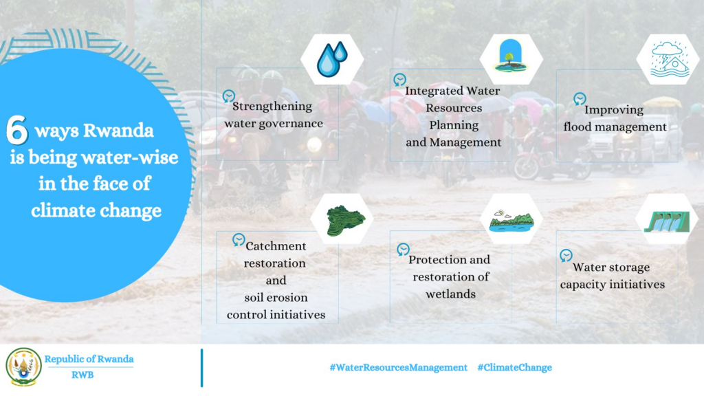
According to Rwanda Water Board, here there are six ways Rwanda is being water wise in the face of climate change:
1. Strengthening Water Governance
1.1. Establishment of the Rwanda Water Resources Board .The Rwanda Water Resources Board was established in 2020 to ensure availability of sufficient and well managed water resources for sustainable development. The government institution is implementing national policies, laws and strategies related to water resources, overseeing integrated planning of water resources, catchment restoration and erosion control, flood management and water storage development. The board also oversees water use efficiency and quality management. The creation of the Rwanda Water Resources Board demonstrates the government’s commitment to being water wise and the importance of water resources in the country’s socio-economic transformation. Learn more about the Rwanda Water Resources Board at www.rwb.rw.
1.2. Creation of Water Permitting System Rwanda’s water resources are under increasing pressure and the country needs to know how much water is used, by whom, and where. Once known, this can be measured against how much water is actually available for use and manage use efficiently and sustainably. Rwanda’s water law on the use and management of water resources gives the Rwanda Water Resources Board the tools to gather the information needed for the optimal management of water resources. The water permits system is one of these tools. Why Water Permits?
· Water Resources Management: To manage the water resources effectively and efficiently for optimal beneficial use of water for economic development of the country. · Fair Share Allocation: To be able to allocate water, the water resources managers must know both how much water is available, and how much is already being used. · Environmental Protection: Water resources managers must ensure that water use is efficient, is well planned, and that pollution is reduced to a minimum. When allocating water resources for different uses, managers have to make sure that water for environmental flow remains available. The Water Permit System is a web application that enables water users to apply for a water permit. The permit system aids in the proper management of water resources. Rwanda’s Water Permit system can be accessed at www.waterpermit.rwb.rw.
Access to water underpins public health and is critical to sustainable development. Availability of water is also critical for any country’s prosperity. The progress made on water access and use was achieved through Integrated Water Resource Management, which contributes to achieving Rwanda’s Green Growth and Climate Resilience Strategy. Here are six ways Rwanda is being water wise in the face of climate change In Rwanda, significant progress has been made to improve access to water by protecting water resources, preventing pollution, controlling soil erosion and mitigating flooding.
1.3. Water Monitoring and Water Resources Portal Rwanda established a system for recording the quantity and quality of its water bodies. Hydrological and hydrogeological data is collected by a network of water monitoring stations installed on rivers and lakes, including automatic and real time data recording and transmission. A water resources portal was created as a web platform where data collected by the monitoring systems water resource and other water related information such as hydrological bulletins, water quality, surface water and ground water reports are stored to make them easily accessible. The portal was established so that the water resources of Rwanda are protected, conserved, managed and developed in an integrated and sustainable manner to facilitating public to access to information related to water use in Rwanda.
The portal is designated for a wide range of users including general public, leaders, policy makers, government institutions, professionals and those in the education sector; with the following benefits: • Quick and easy access to up to date and accurate water resources data; • Increased awareness on water resources in Rwanda; • Increased transparency in accessing to data/information on water resources. Rwanda’s Water Resources Portal can be accessed at www.waterportal.rwb.rw.
2. Integrated Water Resources Planning and Management
2.1. Integrated Water Resources Management Program With the support of the Kingdom of the Netherlands, the Integrated Water Resources Management Program was initiated and implemented, and whose goal is to achieve equitable, efficient and environmentally sustainable water resources in order to support poverty reduction, equitable development, resilience to climate change and conservation of biological diversity. The programme has six strategic focus areas: • Water governance and management • Investment in natural water infrastructure • Water for development • Knowledge development and management • Collaborative partnerships • Climate change, gender, people and rights
2.2. Catchment planning Rwanda is located on the divide of two major basins of Africa (Congo Basin and Nile Basin) and is subdivided into 9 main catchments. Catchment planning is international best practice for integrated management of water, land, and related natural resources, based on the hydrological boundaries of a catchment or watershed. Catchment management plans have been developed for 6 catchments, including detailed water allocation plans while the other 3 plans are under development. Supported by the National Water Resources Master Plan, Rwanda now knows exactly how much water can be allocated to irrigation, industry, livestock, domestic water supplies and to the environment. This quantitative information illustrated likely water scarcity, and the need to revise the irrigation master plan and policy on food production.
3. Improving flood management A number of initiatives have been carried out to address flooding in Kigali and other major cities.
The Rwanda Water Resources Board has established a monitoring system of key flood prone areas to provide time-critical surface water data as well as information on long-term hydrologic conditions and real time in stream stage, flow (discharge). This provide time-critical information for the monitoring of floods, and daily streamflow conditions needed for early warning system and water-supply management. In addition, flood modeling were carried out in critical flood hotspots and the information got shows whether affected properties would have a low, medium or high flood hazard in City of Kigali.
It means different entities people can be prepared for an event as well as planning and development. Furthermore, more than 40 drainage systems have been constructed, a city-wide assessment to identify vulnerable households living in flood prone areas has been conducted and more than 5,000 families living in highrisk zones have been relocated to safer areas.
Flood early warning systems Rwanda has a mountainous topography dominated by steep slopes and on a national surface of 26,338 km2 the difference in elevation goes from 4,507 m to 900 m. Rainfall exceed in some areas 2,000 mm per year. The above particular situation makes the country much vulnerable to floods and landslides especially in the North-Western part of the country which has the highest elevation, intense rainfalls, a rich hydrological network and fragile soils that are easily washed away by water causing soil erosion. Recurrent flash floods are experienced causing loss of lives, damages to infrastructure and properties, as well as disruptions to movements of people, traffic and daily activities of the population.
The Flood Early Warning System was piloted in this critical catchment of Sebeya with the main objective of ensuring safety of communities that are close to Sebeya river and prone to flooding, and minimisation of damages caused by floods in the catchment. Sebeya Flood Early Warning System was developed at 4 high-risk locations where systems for real time water level monitoring and analyzing, mapping flood hazards, flood forecasting and communication system were implemented. Gully protection with lava stones Retention ponds
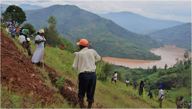
4. Catchment restoration and soil erosion control initiatives
Using a GIS based toll developed to support decision making on catchment restoration (CROM-DSS), RWB conducted a countrywide soil erosion assessment. Areas exposed to soil erosion are classified into categories depending on level of severity: extremely high risk, very high risk, high risk, moderate risk, low risk, and no risk zones of erosion. Soil erosion risk mapping is detailed up to the cell level.
In line with the above soil erosion is controlled through catchment restoration initiatives involving the following practices: progressive and bench/radical terraces, afforestation, agroforestry, silvo-pastoralism, rivers and lakes banks protection, water ways infrastructure, gulley protection, etc. In addition to measures implemented by Districts through own budgets or earmarked funds from central government, other catchment restoration and erosion control projects are implemented across the country by different institutions, under the overall coordination of the Rwanda Water Resources Board, focusing on the most critical areas as identified and mapped using the above mentioned tool.
5. Protection and restoration of wetlands Wetlands degradation and pollution has significantly impacted water quality and quantity.
A declining capacity of wetlands to provide critical ecosystem services results in increased flooding and lives lost, damage to infrastructure, reduced productivity, and silting of water bodies. That is why Rwanda has prioritized wetland restoration, especially in urban areas. The country has recorded a number of achievements in wetlands management, including: • Restoration activities of important wetland ecosystems. For example, the restoration of Rugezi Wetland since 2005 has seen it gain its status as a Ramsar Site and earned a Green Globe Award in 2010. • Major ongoing wetland rehabilitation projects including the Rwanda Urban Development Project II (RUDPII), the Mapping and Categorization of all Wetlands and the relocation of Gikondo Industrial Zone out of the wetland to a more suitable location. • More than 6,000 commercial activities (car garages, vehicle parking and factories) and household activities have been relocated from urban wetlands for them to be rehabilitated. • The development of a wetland masterplan has shown that at least 15 square kilometers, accounting for 20% of city wetlands, will be rehabilitated, while 29% have been recommended for sustainable utilization, 38% for conservation, and the remainder for recreational purposes. Another key achievement is the creation of the Nyandungu Urban Wetland Eco-Tourism Park implemented by Rwanda Environment Management Authority with investment from the Rwanda Green Fund, UN Environment Program and the Italian Government. The eco-tourism park sits on 120 hectares of land in Kigali and features ornamental ponds, gallery forests, medicinal plant gardens, paved walkways and cycle lanes, restaurants, information center, and other recreational services.
The project is designed not only to provide social and economic benefits to the community but also support innovative approaches to restore and conserve wetland ecosystems, and promote the sustainable management of natural resources. Using a GIS based toll developed to support decision making on catchment restoration (CROM-DSS), RWB conducted a countrywide soil erosion assessment. Areas exposed to soil erosion are classified into categories depending on level of severity: extremely high risk, very high risk, high risk, moderate risk, low risk, and no risk zones of erosion. Soil erosion risk mapping is detailed up to the cell level.
6. Water Storage Capacity Initiatives
6.1. Water storage status and future plans Rwanda has a relatively high average rainfall of 1,200 mm annually, making rain water harvesting an attractive alternative source of water to meet increasing demands for human needs, socio-economic development as well as environmental protection. Despite this, Rwanda is considered a water scarce nation due to limited storage capacity. A number of projects have been implemented to deliver on this priority and have informed the potential scale-up of rainwater harvesting across the country. According to the recent Water Storage Status Report, three main artificial storages are considered in Rwanda. These include water ponds used for small scale irrigation, valley dams for livestock watering and dams used for irrigation and hydropower generation. The report showed that Rwanda currently has 1,414 water ponds with a storage capacity of 131,603 m3, 77 valley dams capable of storing more than 8 million m3 of water volume, and 50 dams with an estimated water storage capacity of more than 75 million m3. Efforts are underway to scale up the country’s water storage capacity through multipurpose dam, and improve rainwater harvesting from residential areas.
6.2. Muvumba Multipurpose Water Resources Development Program The program objective is to improve water, energy, food and nutrition security by harnessing water resources for irrigation, domestic, livestock and hydropower use while ensuring sustainability of the resources and building resilience against climate change and variability through catchment protection, and capacity development.
The Program involves Muvumba multipurpose dam project; a government project that intends to construct a dam of 30.5m high and will impound 35 million cubic meter of water in one of the most water scare catchments; Muvumba Catchment. The Project aims to increase the productivity and commercialization of agriculture and livestock products through the implementation of integrated watershed management practices, water-harvesting in main and valley dams, marshland and hillside irrigation. It will help also to increase the quality and quantity of water to supply, hence, in addition to flood control, this project will help to avail water to meet the different demands such as irrigation, livestock water supply, domestic water supply, hydropower generation.